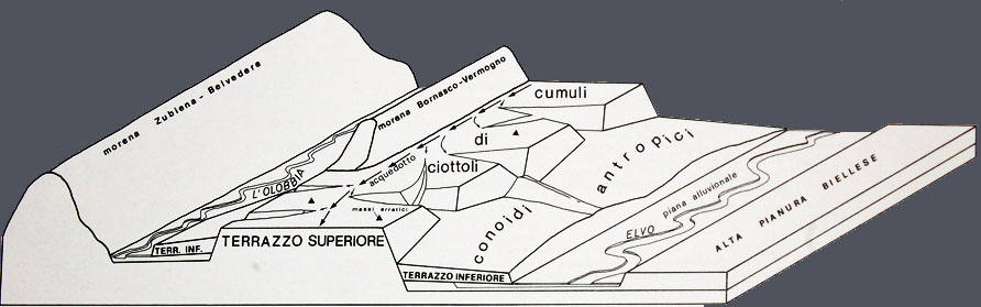
WATER DISTRIBUTION NETWORK
The exploitation of a gold mine of
alluvial origin needed large amount of water as the sand, which contained the metal
as dust or nuggets, had to be "washed". The procedure, was digging
the sediment made of sand and pebbles of different sizes that, gathered and put
aside, formed the big piles that now represent the Bessa landscape. The sand
was then poured into channels (provided with wainscot with weak and constant
slope) where the water flowed together with gold, magnetite and garnet (whose
specific gravity was higher and could then deposit quicker) and finally
collected through different procedures. A second washing, probably with the
classical "plate", still used today by gold prospectors in Elvo
stream, separated gold from the other minerals. The sediment so deprived of
metals was thrown off the slope, towards Elvo (and in the southern part of the
Terrace also towards Olobbia) forming cone dumps. The water for this operation
came from Viona stream and was directed into a channel probably parallel to
Bernasco-Vermogno moraine.
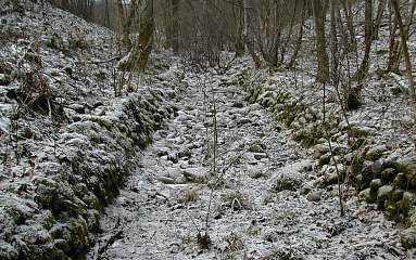
|
channel
in the upper terrace |
|
|
|
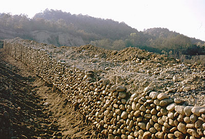
channel in the cone dumps |
The water distribution network, gathered
by the above-mentioned channel, appears still today through several deviations
crossing the Terrace that seem to fill natural streams, previous to the mine
exploitation. Many of these channels, widen during their course, or more often
at the apex (west), into wide flat surfaces slightly leaning towards the plains,
totally or partially surrounded by dry masonry, often funnel-shaped, and where
it is likely that during the night water was collected for using it during the
working hours. These products kept very well until now (with enlargements and
subsequent restructurings) as the surfaces, reclaimed and flattened, were
suitable to be exploited, once their original function was completed. In some
of these basins the feeding channel is still visible.
|
Aerial view (South East) Upper part: piles of pebbles crossed by channels Lower part: cone dumps |
|
The water distribution network cannot be easily identified
in the south-west part of Bessa (between Cascina dell'Apostolo and Cerrione) as
a high number of depressions, where channels should be inserted, present signs
of roadways, irregular slope bottom, interruptions against piles of pebbles or
internal slopes of the Terrace.
Several springs, active or dried, are inside the
Terrace and along its edges and represent the visible "terminal" of
the water, which, infiltrating into the piles, runs through the troughs or
gathers into impermeable depressions. The good condition of the protections
made of semi-circular or rectangular pebbles masonry, with leaning floors or
steps heading to deeper ones, proves the accurate maintenance done up to now.

channels
Bessa after exploitation
(da F.Gianotti)